Saturday, March 31, 2012

Mughal emperors

The Mughal era is a historic period of the Mughal Empire in South Asia (mainly Northern India, North Eastern Pakistan and Bangladesh). It ran from the early 15th century to a point in the early 18th century when the Mughal Emperors' power had dwindled. It ended in several generations of conflicts between rival warlords.

The imperial family directly descended from two of the worlds greatest conquerors: Genghis Khan, founder of the largest contiguous empire in the history of the world; and the Amir, Taimurlong or Tamerlane the Great. The direct ancestors of the Mughal emperors, at one point or another, directly ruled all areas from Eastern Europe to the Sea of Japan, and from the Middle East to Russian Plains. They also ruled some of the most powerful states of the medieval world such as Turkey, Persia, India and China. Their ancestors were further also credited with stabilizing the social, cultural and economic aspects of life between, Europe and Asia and opening the extensive trade route known as the Silk Road that connected various parts of the continent. Due to descent from Genghis Khan, the family was called Mughal, or mogul, persianized version of the former's clan name Mongol.The English word mogul (e.g. media mogul, business mogul) was coined by this dynasty, meaning influential or powerful, or a tycoon. From their descent from Tamerlane, also called the Amir, the family used the title of Mirza, shortened Amirzade, literally meaning 'born of the Amir'.[2] The burial places of the Emperors illustrate their expanding empire, as the first Emperor Babur, born in Uzbekistan is buried in Afghanistan, his sons and grandsons, namely Akbar the Great and Jahangir in India and Pakistan respectively and later descendants, Shah Jahan and Aurangzeb in Hindustan. The last Emperor, Bahadur Shah Zafar is buried in Burma.

They were also a prominent influence of literature in Urdu, Hindi, and Bengali. They have been continuously portrayed in many films, the most famous of which, multi-million dollar Mughal-e-Azam about Emperor Jahangir's love story; considered an Indian classic and epic film and also the Bollywood film Jodhaa Akbar about Emperor Akbar's (Emperor Jahangir's father) love story. Emperor Jahangir's son was the Prince Khurram who later went on to become Emperor Shah Jahan and built one of the seven Wonders of the World, the famous Taj Mahal to memorialize his love for his wife.

Mughal Empire


The Taj Mahal - the most famous structure in India built during Mughal Era
The Mughal Empire lasted for more than three centuries. The Mughal Empire was one of the largest centralized states in pre-modern history and was the precursor to the British Indian Empire.
The titles of the first of the six Mughal Emperors receive varying degrees of prominence in present-day Pakistan and India. Some favour Babur the pioneer and others his great-grandson, Shah Jahan (r. 1628-58), builder of the Taj Mahal and other magnificent buildings. The other two prominent rulers were Akbar (r. 1556-1605) and Aurangzeb (r. 1658-1707). Both rulers expanded the empire greatly and were able administrators. However, Akbar was known for his religious tolerance and administrative genius, whereas Aurangzeb was a just ruler but a proselytizer of orthodox Islam across the heterodox Indian landscape.

Babur

Babur was the first Mughal emperor. He was born on 14 Feb 1483 in present day Uzbekistan, the eldest son of Amir Umar Shaykh Mirza, the son of Abū Saʿīd Mirza (and grandson of [Miran Shah], who was himself son of Timur) and his wife Qutlugh Nigar Khanum, daughter of Younus Khan, the ruler of Moghulistan (and great-great grandson of [abhavh Timur]], the son of Esen Buqa II, who was the great-great-great grandson of Chaghatai Khan, the second born son of Genghis Khan). Babur was known for his love of beauty in addition to his military ability. Babur concentrated on gaining control of northwestern India.He was invited to India by Daulat Khan Lodi and Rana Sanga who wanted to end the Lodi dynasty. He defeated Ibrahim Lodi in 1526 at the First battle of Panipat, a town north of Delhi. In 1527 he defeated Rana Sanga, rajput rulers and allies at khanua. Babur then turned to the tasks of persuading his Central Asian followers to stay on in India and of overcoming other contenders for power, mainly the Rajputs and the Afghans. He succeeded in both tasks but died shortly thereafter on 25 December 1530 in Agra. He was later buried in Kabul.

Babur kept the record of his life in Chagatay Turkish, the spoken language of the Timurids and the whole Turco-Mongol world at the time. Baburnama is one of the longest examples of sustained narrative prose in Chagatai Turkish. Akbar's regent, Bairam Khan, a Turcoman of eastern Anatolian and Azerbaijani origin whose father and grandfather had joined Babur's service. Bayram Khan wrote poetry in Chaghatai and Persian. His son, Abdul-Rahim Khankhanan, was fluent in Chaghatai, Hindi, and Persian and composed in all three languages. Using Babur's own text he translated the Baburnama into Persian. The Chaghatai original was last seen in the imperial library sometime between 1628 and 1638 during Jahangir's reign.

Humayun

Babur’s favorite son Humayun took the reins of the empire after his father succumbed to disease at the young age of forty-seven.
In 1539, Humayun and Sher Khan met in battle in Chausa, between Varanasi and Patna. Humayun barely escaped with his own life and in the next year, in 1540, his army of 40,000 lost to the Afghan army of 15,000 of Sher Khan. A popular Pashtun Afghan General "Khulas Khan Marwat" was leading Sher Shah Suri's Army. This was the first Military Adventure of Khulas Khan Marwat and he became soon, a nightmare for Mughals.
Sher Khan's Army under the command of Khulas Khan Marwat had now become the monarch in Delhi under the name Sher Shah Suri and ruled from 1540 to 1545. Sher Shah Suri consolidated his kingdom from Punjab to Bengal (the first to enter Bengal after Ala-ud-din Khilji, more than two centuries earlier). He was credited with having organized and administered the government and military in such a way that future Mughal kings used it as their own models. He also added to the fort in Delhi (supposed site of Indraprastha), first started by Humayun, and now called the Purana Qila (Old Fort). The Masjid Qila-i-Kuhna inside the fort is a masterpiece of the period, though only parts of it have survived.

The charred remains of Sher Shah were taken to a tomb at Sasaram (in present day Bihar), midway between Varanasi and Gaya. Although rarely visited, the future great Mughal builders like Akbar, Jahangir and Shah Jahan emulated the architecture of this tomb. The massive palace-like mausoleum is three stories and fifty meters high., Sher Shah’s son Islam Shah held on to power until 1553 and following his death the Sur dynasty lost most of its clout due to strife and famine.

Humayun was a keen astronomer, and in fact he died due to a fall from the rooftop of Sher Shah’s Delhi palace in 1556. Thus Humayun ruled in India barely for ten years and died at the age of forty-eight, leaving behind Akbar then only thirteen-year-old as his heir. As a tribute to his father, Akbar later built the Humayun’s tomb in Delhi (completed in 1571), from red sandstone, that would become the precursor of future Mughal architecture. Akbar’s mother and Humayun’s wife Hamida Banu Begum personally supervised the building of the tomb in his birth place.

Akbar

Akbar succeeded his father, Humayun whose rule was interrupted by the Afghan Sur Dynasty, which rebelled against him. It was only just before his death that Humayun was able to regain the empire and leave it to his son. In restoring and expanding Mughal rule, Akbar based his authority on the ability and loyalty of his followers, irrespective of their religion. In 1564 the jizya tax on non-Muslims was abolished, and bans on temple building and Hindu pilgrimages were lifted.

Akbar's methods of administration reinforced his power against two possible sources of challenge—the Afghan-Turkish aristocracy and the traditional interpreters of Islamic law, the ulama. He created a ranked imperial service based on ability rather than birth, whose members were obliged to serve wherever required. They were remunerated with cash rather than land and were kept away from their inherited estates, thus centralizing the imperial power base and assuring its supremacy. The military and political functions of the imperial service were separate from those of revenue collection, which was supervised by the imperial treasury. This system of administration, known as the mansabdari, was based on loyal service and cash payments and was the backbone of the Mughal Empire; its effectiveness depended on personal loyalty to the emperor and his ability and willingness to choose, remunerate, and supervise.

Akbar declared himself the final arbiter in all disputes of law derived from the Qur'an and the sharia. He backed his religious authority primarily with his authority in the state. In 1580 he also initiated a syncretic court religion called the Din-i-Ilahi (Divine Faith). In theory, the new faith was compatible with any other, provided that the devotee was loyal to the emperor. In practice, however, its ritual and content profoundly offended orthodox Muslims. The ulema found their influence undermined.

Several well known heritage sites were built during the reign of Akbar. The fort city of Fatehpur Sikri was used as the political capital of the Empire from 1571 to 1578. The numerous palaces and the grand entrances with intricate art work have been recognized as a world heritage site by UNESCO. Akbar also began construction of his own tomb at Sikandra near Agra in 1600 CE.

Jahangir


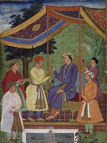
Mughal Emperor Jahangir receiving his two sons, in 1605-06.
Prince Salim (b. 1569 son of Hindu Rajput princess from Amber), who would later be known as Emperor Jahangir showed signs of restlessness at the end of a long reign by his father Akbar. During the absence of his father from Agra he pronounced himself as the king and turned rebellious. Akbar was able to wrestle the throne back. Salim did not have to worry about his sibling’s aspirations to the throne. His two brothers, Murad and Daniyal, had both died early from alcoholism.
Jahangir began his era as a Mughal emperor after the death of Akbar in the year 1605. He considered his third son Prince Khurram (future Shah Jahan-born 1592 of Hindu Rajput princess Manmati), his favourite. Rana of Mewar and Prince Khurram had a standoff that resulted in a treaty acceptable to both parties. Khurram was kept busy with several campaigns in Bengal and Kashmir. Jahangir claimed the victories of Khurram – Shah Jahan as his own.

Shah Jahan


Shah Jahan on a Terrace Holding a Pendant Set with His Portrait.jpg
Prince Khurram, who would later be known as Emperor Shah Jahan, ascended to the throne after a tumultuous succession battle. With the wealth created by Akbar, the Mughal kingdom was probably the richest in the world. Prince Khurram gave himself the title of Shah Jahan, the ‘King of the World’ and this was the name that was immortalized by history. With his imagination and aspiration, Shah Jahan gained a reputation as an aesthete par excellence. He built the black marble pavilion at the Shalimar Gardens in Srinagar and a white marble palace in Ajmer. He also built a tomb for his father, Jahangir in Lahore and built a massive city Shahajanabad in Delhi but his imagination surpassed all Mughal glory in his most famous building the Taj Mahal. It was in Shahajanabad that his daughter Jahanara built the marketplace called Chandni Chowk.
His beloved wife Arjuman Banu (daughter of Asaf Khan and niece of Nur Jahan) died while delivering their fourteenth child in the year 1631. The distraught emperor started building a memorial for her the following year. The Taj Mahal, named for Arjuman Banu, who was called Mumtaz Mahal, became one of the Seven Wonders of the World.
The great Jama Masjid built by him was the largest in India at the time. He renamed Delhi after himself as Shahjahanabad. The Red Fort made of red sandstone built during his reign near Jama Masjid around the same time came to be regarded as the seat of power of India itself. The Prime Minister of India addresses the nation from the ramparts of this fort on Independence day even to this age.Shah Jahan also built or renovated forts in Delhi and in Agra. White marble chambers that served as living quarters and other halls for public audiences are examples of classic Mughal architecture. Here in Agra fort, Shah Jahan would spend eight of his last years as a prisoner of his son, Aurangzeb shuffling between the hallways of the palace, squinting at the distant silhouette of his famous Taj Mahal on the banks of River Jamuna..

Aurangzeb

Aurangzeb, who was given the title "Alamgir" or "world-seizer," by his father, is known for expanding the empire's frontiers and for his acceptance of Islam law. During his reign, the Mughal empire reached its greatest extent (the Bijapur and Golconda Sultanates which had been reduced to vassalage by Shah Jahan were formally annexed).
In 1679, Aurangzeb enforced the jizyah tax on Non-Muslims like Zakāt tax was enforced on Muslims. This action by the emperor, incited rebellion among Hindus and others in many parts of the empire notably the Jats, Sikhs, and Rajputs forces in the north and Maratha forces in the Deccan. The emperor managed to crush the rebellions in the north. Aurangzeb was compelled to move his headquarters to Aurangabad in the Deccan to mount a costly campaign against Maratha guerrilla fighters led by Shivaji and his successors, which lasted twenty-six years until he died in 1707 at the age of eighty-nine.

Bangladeshi animals

The Royal Bengal Tiger

The majestic Royal Bengal Tiger is the national animal Bangladesh. Highly endangered, the Royal Bengal can now be mostly be found in the Sundarbans.
One of the largest of the 'big cats', it has extremely bold and striking colour pattern - making it perhaps the most magnificent and sought-after fiery beast of the world!  The vivid pattern of stripes on the glossy skin serves as a very effective camouflage in the grasses and foliage almost in all the seasons.
The male averages 3 metres in length including 1 meter of tail and wiighs about 180 kg., though much larger speciemens have been lnown.  The giant one is the Siberian tiger, almost 4 metres long and weighing about 300 kg.


Deers

The Sambar Deer is the most widely spread deer species in the world, covering many countries in the Asian continent. It is also one of the larger members of the deer family. Some males are known to weigh up to 300 kgs and can grow to a height ranging from 135 - 150 cms at the shoulders.
These animals have a life expectancy ranging between 16 - 20 years. They are the favourite prey species of the tiger. A large sambar can feed a feed tiger for up to 4 days. Unlike the Spotted deer, which shouts an alarm and darts away at the sight of a predator, the sambar tends to alertly watch and keep giving alarm calls until the danger has passed. A reason due to which many of them fall prey for predators. The Sambar can be found in the wooded hills of the north-east and east.

The Barking Deer

The Chital Deer
The Chital (spotted deer) is also very common in the forests of the Sundarban. The Chital is perhaps the most beautiful of all deer. Its coat is bright rufous-fawn profusely spotted with white at all ages and all seasons. They are seen in herds of 10-30, which contains 2-3 stags. They are seen in grassy forest glades, forest edges, woodland and shaded streams in moist and dry deciduous forests upto 1000 m. Average height is 36 in. (90 cm.) and weighs about 190 lb. (85 kg.)
The barking deers are small deer of the forests. They are noted for barking like dogs when alarmed and during the breeding season, and for having tiny antlers and tusklike canine teeth.

Apes and Monkeys

Primates  also abound all over Bangladesh, but most abundantly in the Sundarbans and the Hill Tracts.
Amongst the various species you will find the Hoolock Gibbon (the only ape in the subcontinent) as wells as langurs, and various species' of monkeys.
Hoolock gibbons mate for life and defend their territories with whistling songs that echo through the forests in the early mornings, giving rise to their nickname of the "singing ape."

Elephants

The elephant is mostly found in the wild in the Hill Tracts and is also a protected animal.
Elephant habitat in Bangladesh is confined almost entirely to the forested hills of the east, and even there habitat is giving way to monoculture plantations of teak, rubber, and tea.
Only 200-350 wild elephants are thought to survive, with herds moving between Bangladesh and neighbouring India.
There may be around 50 domestic elephants.

Bay of Bengal

Etymology


The Bay of Bengal at the beach of Gopalpur.
The Bay of Bengal appears as Sinus Gangeticus or Gangeticus Sinus, meaning "Gulf of the Ganges", in ancient maps. In the 10th century the explosion of Indianized kingdoms, led by the Chola Empire, resulted in the Bay of Bengal being known as the Chola Lake. It later came to be known as Bay of Bengal in after the region of Bengal.

Rivers

Many major rivers of the Indian subcontinent flow west to east through Bangladesh into the Bay of Bengal: in the north, the Padma River (or Ganges), Meghna River and Brahmaputra River rivers, and in the south Mahanadi River through the Mahanadi River Delta, Godavari River, Krishna river, Irrawaddy and Kaveri River (sometimes written as Cauvery) rivers. The shortest classified river which drains into the Bay of Bengal is Cooum River at 64 km (40 mi). Brahmaputra is the 28th longest River in the World 2,948 km (1,832 mi), and it discharges into the 'Bay of Bengal' and travels mainly through China, Assam and Bangladesh. The Sundarbans mangrove forest is formed at the delta of the Ganges, Brahmaputra and Meghna rivers on the Bay of Bengal. The Ayeyarwady River of Myanmar also flows into the bay and once had thick mangrove forest of its own.

Islands

The islands in the bay are very numerous, including the Andaman Islands, Nicobar and Mergui groups of India. The group of islands, Cheduba and others, in the north-east, off the Burmese coast, are remarkable for a chain of mud volcanoes, which are occasionally active. Great Andaman is the main archipelago or island group of the Andaman Islands, whereas Ritchie's Archipelago consists of smaller islands. Only 37 of the 572 islands and islets of the Andaman and Nicobar Islands are inhabited, or 6.5%.

Beaches


Cox's Bazar, the longest stretch of beach in the world.
Sunrise at Kuakata
Sunrise at Kuakata
Sunset at Kuakata
Kuakata beach in Bangaldesh, one of the sea beaches of Bay of Bengal where from same location both sunrise and sunset at sea can be observed. Puri in Orissa, India has a beautiful beach from where both sunrise and sunset can be seen.
Sea Beach Location
Cox's Bazar Bangladesh
Kuakata Bangladesh
St. Martin's Island Bangladesh
Bakkhali India
Digha India
Mandarmani India
Chandipur India
Puri India
Waltair India
Marina Beach India
Ngapali Burma
Arugram Sri Lanka

Oceanography

The Bay of Bengal is a salt water sea and is a part of the Indian Ocean.

Plate tectonics


Floor of Bay of Bengal
  The Indian plate, shown in red
  The Indo-Australian plate, shown in dull orange
The lithosphere of the earth is broken up into what are called tectonic plates. Underneath the Bay of Bengal is the Indian Plate which is part of the great Indo-Australian Plate and is slowly moving north east. This plate meets the Burma Microplate at the Sunda Trench. The Nicobar Islands, and the Andaman Islands are part of the Burma Microplate. The India Plate subducts beneath the Burma Plate at the Sunda Trench or Java Trench. Here, the pressure of the two plates on each other increase pressure and temperature resulting in the formation of volcanoes such as the volcanoes in Myanmar, and a volcanic arc called the Sunda Arc. Sumatra-Andaman earthquake and Asian Tsunami was a result of the pressure at this zone causing a submarine earthquake which then resulted in a huge Tsunami.

Marine geology

A zone 50 m wide extending from the island of Ceylon and the Coromandel coast to the head of the bay, and thence southwards through a strip embracing the Andaman and Nicobar islands, is bounded by the 100 fathom line of sea bottom; some 50 m. beyond this lies the 500-fathom limit. Opposite the mouth of the Ganges, however, the intervals between these depths are very much extended by deltaic influence.

Swatch of No Ground is a 14 km-wide deep sea canyon of the Bay of Bengal. The deepest recorded area of this valley is about 1340 m. The submarine canyon is part of the Bengal Fan, the largest submarine fan in the world

Marine biology, flora and faun

The Sunderbans bordering the Bay of Bengal is the largest single block of tidal halophytic mangrove forest in the world.

The Bay of Bengal is full of biological diversity, diverging amongst coral reefs, estuaries, fish spawning and nursery areas, and mangroves. The Bay of Bengal is one of the World's 64 largest marine ecosystems.

Kerilia jerdonii is a sea snake of the Bay of Bengal. Glory of Bengal Cone (Conus bengalensis) is just one of the seashells which can be photographed along beaches of the Bay of Bengal.[13] An endangered species, the Olive Ridley sea turtle can survive because of the nesting grounds made available at the Gahirmatha Marine Wildlife Sanctuary, Gahirmatha Beach, Orissa, India. Marlin, barracuda, skipjack tuna, (Katsuwonus pelamis), yellowfin tuna, Indo-Pacific humpbacked dolphin (Sousa chinensis), and Bryde's whale (Balaenoptera edeni) are a few of the marine animals. Bay of Bengal Hogfish (Bodianus neilli) is a type of Wrass which live in turbid lagoon reefs or shallow coastal reefs. Schools of dolphins can be seen, whether they are the bottle nose dolphin (Tursiops truncatus), Pantropical spotted dolphin (Stenella attenuata) or the spinner dolphin (Stenella longirostris) . Tuna and dolphins are usually residing in the same waters. In shallower and warmer coastal waters the Irrawaddy Dolphins (Orcaella brevirostris) can be found.

The Great Nicobar Biosphere Reserve provides sanctuary to many animals some of which include the saltwater crocodile (Crocodylus porosus), giant Leatherback Sea Turtle (Dermochelys coriacea), and Malayan box turtle (Cuora amboinensis kamaroma) to name a few.

Another endangered species Royal Bengal Tiger is supported by Sundarbans a large estuarine delta that holds a mangrove area in the Ganges River Delta.
Chemical oceanography

Coastal regions bordering the Bay of Bengal are rich in minerals. Sri Lanka, Serendib, or Ratna – Dweepa which means Gem Island. Amethyst, beryl, ruby, sapphire, topaz, and garnet are just some of the gems of Sri Lanka. Garnet and other precious gems are also found in abundance in the Indian states of Orissa and

Andhra Pradesh.
Physical oceanography - climate of the Bay of Bengal

From January to October, the current is northward flowing, and the clockwise circulation pattern is called the "East Indian Current." The Bay of Bengal monsoon moves in a northwest direction striking the Nicobar Islands, and the Andaman Islands first end of May, then the North Eastern Coast of India by end of June.

The remainder of the year, the counterclockwise current is southwestward flowing, and the circulation pattern is called the East Indian Winter Jet. September and December see very active weather, season varsha (or monsoon), in the Bay of Bengal producing severe Cyclones which affect Eastern India. Several efforts have been initiated to cope with Storm surge

Himalaya

the Himalaya Range or Himalaya Mountains (play /ˌhɪməˈleɪ.ə/ or /hɪˈmɑːləjə/;[1][2] Sanskrit: Devanagari: हिमालय, literally "abode of snow"), usually called the Himalayas or Himalaya for short, is a mountain range immediately at the north of the Indian subcontinent. By extension, it is also the name of a massive mountain system that includes the Karakoram, the Hindu Kush, and other, lesser, ranges that extend out from the Pamir Knot.

Together, the Himalayan mountain system is the world's highest, and home to the world's highest peaks, the Eight-thousanders, which include Mount Everest and K2. To comprehend the enormous scale of this mountain range, consider that Aconcagua, in the Andes, at 6,962 metres (22,841 ft) is the highest peak outside Asia, whereas the Himalayan system includes over 100 mountains exceeding 7,200 m (23,600 ft). However the Alleghenian mountains, formed during the formation of Pangaea, likely rivalled or exceeded the Himalayas in height.

The main Himalayan range runs west to east, from the Indus river valley to the Brahmaputra river valley, forming an arc 2,400 km (1,500 mi) long, which varies in width from 400 km (250 mi) in the western Kashmir-Xinjiang region to 150 km (93 mi) in the eastern Tibet-Arunachal Pradesh region. The range consists of three coextensive sub-ranges, with the northernmost, and highest, known as the Great or Inner Himalayas.

Some of the world's major river systems arise in the Himalayas, and their combined drainage basin is home to some 3 billion people (almost half of Earth's population) in 18 countries. The Himalayas have profoundly shaped the cultures of South Asia; many Himalayan peaks are sacred in Hinduism, Buddhism and Sikhism.

Geologically, the origin of the Himalayas is the impact of the Indian tectonic plate traveling northward at 15 cm per year to impact the Eurasian continent, with first contact about 70 million years ago, and with movement continuing today. The formation of the Himalayan arc peaks eventually resulted from this, since the lighter rock of the seabeds of that time were easily uplifted into mountains. An often-cited fact used to illustrate this process is that the summit of Mount Everest is made of marine limestone

Shah Jalal

Shah Jalal (Persian: شاه جلال‎; Bengali: শাহ জালাল full name:Yamanī Shāh Jalāl ad-Dīn al-Mujarrad) is a celebrated Sufi Muslim figure in Bengal. Jalal's name is associated with the Muslim conquest of north-eastern Bengal and the spread of Islam in Bangladesh through the Sufi Movement. He was buried in Sylhet, Bangladesh,formerly known as Jalalabad, while the country's main airport is named in his honour.

Early life and education

Born Makhdum Jalāl ad-Dīn bin Muhammad, he was named al-Mujarrad (probably for his lifelong celibacy or performing of prayers in solitary milieu) and entitled Shaykh-ul-Mashāykh ("Great Scholar"). Shah Jalal's date and place of birth is not certain. Various traditions and historical documents differ. A number of scholars have claimed that he was born in 1271 CE in Konya in modern day Turkey and later moved to Yemen either as a child or adult while the majority believe he was born in a place called Quni in Hadramaut. He was the son of a Muslim cleric, who was a contemporary of the Persian poet and Sufi mystic, Jalal ad-Din Muhammad Rumi but was educated and raised by his maternal uncle Syed Ahmed Kabir in Mecca. He excelled in his studies and became a Hafiz there, increasing proficiency in Islamic theology (aqidah). He achieved spiritual perfection (kamaliyyah) after 30 years of study, practice and meditation.

Travel to India

According to legend, one day his uncle, Sheikh Kabir gave Shah Jalal a handful of soil and asked him to travel to India. He instructed him to choose to settle and propagate Islam in any place in India where the soil exactly matched that which he gave him in smell and color. Shah Jalal journeyed eastward and reached India in c. 1300, where he met many great scholars and Sufi mystics. According to Sheikh Fariduddin Attar's Tajkirat-ul-Auliya, Shah Jajal was born in Yemen in 1322 and died in 1384 which appears to be incorrect since Shah Jalal met Khaja Moinuddin Chishti and Nizamuddin Auliya in Delhi in the year c.1300 which is historically proven and the author Fariduddin Attar was born in the year c.1092 and died in hands of the Tatars within 100 year.

Conquest of Sylhet

During the conquest of Sylhet a king named Gaur Govinda ruled the Sylhet area, then the kingdom of Gauda which was predominantly inhabited by Mongoloid Tepra tribe of Tripura. According to a tradition, a Muslim named Sheikh Burhanuddin living in his reign once sacrificed a cow to celebrate the birth of his son. A crow snatched a piece of the dead meat and dropped it onto the house of a Brahmin Hindu, for whom cows were sacred. According to another tradition, the piece of flesh fell on the temple of the king himself, which he took as a great offense. On the orders of the king, Burhanuddin's hands were said to have been cut off and his son killed. Burhanuddin went to the Sultan of Gauda Shamsuddin Firuz Shah and made plea to him for justice. The Sultan accordingly sent an army under the command of his nephew Sikandar Khan Ghazi who, however, stopped due to heavy downpour and flooding that year. The Sultan then ordered his Sipah Salar (Military commander) Nasiruddin to lead the war.
Shah Jalal, who was at the time residing in Delhi, was requested by Nizam Uddin Auliya at the behest of the Sultan to travel to Bengal along with Sikander to rescue Burhanuddin. With 360 followers, including his nephew Shah Paran, he reached Bengal and joined the Muslim army in the what is to be the conquest of Sylhet.
Knowing that Shah Jalal was advancing towards his kingdom, Raja Govinda removed all ferry boats from the river Surma, thereby cutting off any means of crossing into Gauda. Legend has it that Shah Jalal crossed the river Surma by sitting on a prayer rug. Upon reaching the bank, he ordered the Adhan to be sounded, at which the magnificent palace of the king shattered. With aid of Shah Jalal's help, the Muslim army crushed the Hindu Gauda army and the region of Sylhet was conquered.
However, an inscription from Sylhet (dated 1512-13) says that it was Sikandar Khan Ghazi who had actually conquered the town in the year 1303-4.
The tradition went on to say how Shah Jalal found a match for the soil that his uncle once gave him and therefore settled in Sylhet near Choukidhiki. It is from here that he preached Islam and became a celebrated Muslim figure in Bengal. He and his disciples such as Shah Paran, Shah Malek Yamani, Syed Ahmad Kolla Shahid, Syed Nasiruddin, Haji Darya and Sheikh Ali Yamani traveled as far as Mymensingh to spread Islam in Dhaka, Comilla and the region of Pargana Taraf. Expeditions to Chittagong and Sunamganj were also led respectively by Khwaja Burhanuddin Qattan and Shah Badruddin and by Shah Kamal Qattani, whose shrine is located in Shaharpara, Sunamganj.

Later life

During the later stages of his life, Shah Jalal devoted himself to propagating Islam. Under his guidance, thousands of Hindus and Buddhists converted to Islam. Shah Jalal became so renowned that even the world famous Ibn Battuta, then in Chittagong, was asked to change his plans and go to Sylhet to meet this great saint. On his way to Sylhet, Ibn Batuta was greeted by several of Shah Jalal (R.A)'s disciples who had come to assist him on his journey many days before he had arrived. Once in the presence of Shah Jalal (R.A), Ibn Batuta noted that Shah Jalal (R.A) was tall and lean, fair in complexion and lived by the mosque in a cave, where his only item of value was a goat from which he extracted milk, butter, and yogurt. He observed that the companions of the sheikh were foreign and known for their strength and bravery. He also mentions that many people would visit the sheikh to seek guidance. Shah Jalal (R.A) was therefore instrumental in the spread of Islam throughout north east India, including Assam.
The meeting between Ibn Batuta and Shah Jalal is described in his travelogue in Arabic, Riḥlah Ibn Baṭūṭa (the Journey of Ibn Batuta). Amir Khusrau also gives an account of Shah Jalal's conquest of Sylhet in his book "Afdalul Hawaade". Even today in Hadramaut, Yemen, Sheikh Makhdum Jalaluddin's name is established in folklore.
The exact date of his death is unknown, but he is reported by Ibn Battuta to have died in 746 AH (1347 A.D). He left behind two descendants with many still living in Sylhet today. He is buried in Sylhet in his Dargah (tomb), which is located in a neighbourhood now known as Dargah Mohalla. His shrine is famous in Sylhet and throughout Bangladesh, with hundreds of devotees visiting daily. At the Dargah is also located the largest mosque in Sylhet, one of the largest in the country.

Hazrat Shah Jalal and his 360 disciples

I am doing some research on Hazrat Shah Jalal (RA) and the 360 awliya who were with him during the conquest of Sylhet in modern day Bangladesh. The Sheikh was originally from Yemen and travelled to the region on the command of his sheikh. During his travels many people joined him. I am trying to get his biography in English and possibly biographies of the 360 awliya who were with him. There are books in Bangla, but they are difficult to get hold of.

JazakAllah.

Shah Jalal is one of the most revered legendary Islamic heroes of Bangladesh and one of the key founding fathers of Islam in the country. He was a great saint and a great warrior. He, along with his disciples, had unique contribution in liberating the people of Sylhet region both from the racial rule of the Hindu kings and the prejudices of paganism.

His full full name is Sheikh-ul Mashaek Mokhdum Sheikh Shah Jalal Mozorrodh Bin Muhammed. Although historians are divided on the issue of his birth-palce, the majority of them thinks that he was born in 1271 in Konya, Turky.

Shah Jalal's father was contemporary to Mawlana Jalal Uddin Rumi. Rumi's mazaar is also situated in Shah Jalal's birthplace, Konya in Turky. His ancestors came from Yemen, hence he is also called the Mozorrodh-e-Yemeni. Shah Jalal was raised by his maternal uncle, Syed Ahemd Kabir, in Mecca. He became a Hafiz (those who know the Holy Koran by heart) and also became proficient in Islamic theology. Legend has it that one day his uncle gave him a handful of earth and ask him to go to Hindustan with the instruction that whichever place in Hindustan matches this earth completely in smell and color, he should settle down for preaching and establishing Islam.

Shah Jalal journeyed eastward and reached Hindustan (modern India) in c. 1300. In Ajmir, he met the great Sufi mystic (Dervish/Pir), Kwaja Gharibnawaz Moinuddin Hasan Chisty. He also met with Nizam Uddin Awlia (1236-1325), a prominent Dervish, in Delhi. Nizam Uddin requested him to go to Sylhet to rescue Sheikh Burhan Uddin. The Sheikh was only a handful of Muslims living in the kingdom of a Hindu King, Gaur Gavindha. He secretly slaughtered a cow to perform his son's Akika (christening of child in Muslim culture). It is said that a crow carried a piece of meat and dropped it in the king's yard. The enraged king ordered killing of the Sheikh's son and the Sheikh himself was imprisoned. Sheikh Burhan Uddin's mazaar (shrine) is located in the banks of river Surma in Sylhet town.

Shah Jalal reached Sylhet with 360 Awlias (disciples). Some of the awlias originally followed him from Delhi, and some joined on the way to Sylhet. Knowing that Shah Jalal was advancing toward Sylhet, the king removed all ferry boats from the river Surma. Legend has it that Shah Jalal crossed the river Surma by sitting in a Zainamaaz (prayer rug). Muslim force was defeated by the king twice previously. However, this time the king ran away after being deafeated by the force led by Shah Jalal after a fierce battle. Shah Jalal also found a match of the earth his uncle once gave him. He settled down in a placed called Drag Mahallah, near Choukidhiki. He preached Islam from there. He and his disciples also travelled as far as Mymensingh and Dhaka.

In his book "Afdalul Hawaade", poet Hazrat Amir Khosru gave exact dates of Shah Jalal's travel to Sylhet. Khosru was a Moghul court poet, and considered the founder of Urdu language. Persian traveller, Ibn Batuta, also came to Sylhet to meet Shah Jalal.

The exact date of his death is unknown. According to Ibn Batuta, it was 1347. He died at Sylhet, Bangladesh.

Shah Jalal's nephew, Hazrat Shah Paran, lived out of town, in Major Tila area. Legend says that he was of very high temper and would curse people when they are unruly and the curse would come true. To save people from his wrath, Shah Jalal ordered him to settle down just the outskirt of the town.
 

Michael Madhusudan Dutt

Christians Who Changed their World
Calcutta
Background
Michael Madhusudan Dutt was born to Rajnarayan Dutt and Jahnabi Devi in Sagordari, Jessore District in East Bengal (now in Bangladesh). Rajnarayan Dutt was a famous lawyer. Madhusudan’s formal education started in a school in the village of Shekpura, where he studied Persian. His intellectual and literary talents and imagination were quickly recognized. His parents decided to give him an English education, so he studied European literature at home before being sent to the prestigious Hindu College in Kolkata (i.e. Calcutta) in 1833.
At Hindu College, Dutt studied Bengali, Sanskrit, and Persian, among other subjects. He also began writing poetry. In 1834, he attracted a great deal of attention by reciting a poem he had composed at a public event at the college. By 1842, he was publishing poems in English and Bengali in a number of literary journals in India.
Hindu College had been the site of a number of conversions to Christianity under the influence of one of its teachers, Henry Vincent Vivian Derozio, who ironically was an atheist himself. Derozio had died of cholera in 1831, two years prior to Dutt’s arrival at the school, but his spirit of free inquiry continued to be part of the school’s ethos. Among other things, this meant that Dutt was exposed to Christianity, in particular through the work of Krishna Mohan Bannerjee.

In 1843, Dutt converted to Christianity at Fort William in Kolkata and took the name Michael. His conversion was part of an attempt to avoid an arranged marriage with a Hindu girl, but within months it was obvious that he was serious about it; he even contemplated becoming a missionary. It is also clear Bannerjee was a major influence on his decision. At this point in his career, Bannerjee was following the lead of missionaries like Alexander Duff and attacking Hinduism as superstitious nonsense. Dutt wrote a hymn to be recited at his baptism that echoes these ideas:
Long sunk in superstition’s night,
By Sin and Satan driven,
I saw not, cared not for the light
That leads the blind to Heaven.
But now, at length thy grace, O Lord!
Birds all around me shine;
I drink thy sweet, thy precious word,
I kneel before thy shrine!

His work begins
Dutt’s conversion caused him a great deal of trouble. His family disowned him, and he had to leave Hindu College since at that time it did not teach Christian students. His education resumed in November, 1844, when he was accepted into Bishop’s College, Kolkata, where he remained until 1847. While there, he mastered Latin as well as classical and koine Greek.
When Dutt graduated from Bishop’s College, he moved to Madras, where he took a variety of jobs: he was a teacher at the Madras Orphan Asylum, a “second tutor” at Madras University, and a writer and editor for a variety of literary journals. Dutt’s social life focused on the English and Anglo-Indian communities. He was an Anglophile and was thoroughly convinced of the superiority of the European tradition of rationalistic free inquiry over the tradition-bound culture of India.
Dutt’s poetry was heavily influenced by English poetry, which he considered far superior to Indian verse. One of his first major poems was called The Captive Ladie (1849). It was an Indian story, but the style owed far more to Lord Byron (one of Dutt’s favorite poets) than to Indian poetry. It was quite well received when it came out. That same year, he published Visions of the Past, a long poem recounting the Christian story of the temptation, fall, and redemption of humanity. This was written in blank verse and was heavily influenced by John Milton’s Paradise Lost. He would later write a sonnet entitled, “Satan,” which drew from Milton’s depiction of Satan in Paradise Lost and was an all but perfect imitation of Milton’s style.
Dutt married twice, both times to women of English descent. In Madras, he married an English orphan named Rebecca Mactavys. They had four children. His second wife was Henrietta Sophia White; they had two children.

Poetry
Dutt’s father died, which opened the door for his return to Kolkata in 1856. He continued to publish poetry in English and Bengali. Although it seems that he was more interested in English poetry, his work in Bengali was far more important, far more influential, and far better received. He began writing sonnets in Bengali, and in the 1859 play Sharmistha (English Sermista) he produced the first blank verse in Bengali.
The work which catapulted him to fame was Meghnadh Badh Kabya (The Saga of Meghnadh’s Killing), published in 1861, an epic poem inspired by Homer and Dante but based on the ancient Sanskrit poem Ramayana. In the original, Ravana was a powerful demon king and the villain of the piece. Meghnadh was his son, and was heavily involved in a war between Ravana and Rama, an avatar of Vishnu. Meghnadh was invincible in battle as long as he completed a ritual beforehand; Rama’s brother Lakshmana disrupted the ritual, however, and after battling for three days managed to kill Meghnadh.
Dutt turned this story on its head by portraying Ravana as a good and noble king, and Meghnadh similarly as a patriot, a loving family man, and an honorable and just warrior, much like Hector in the Iliad. In fact, in the Iliad Hector comes across as far more honorable than Achilles, who kills him in a vendetta. This is very similar to the way Dutt portrays Meghnadh and Lakshmana, though the details of the set up and story line are different.
Meghnadh Badh Kabya initiated a renaissance in Bengali poetry; in fact this poem and Dutt’s other work in Bengali helped solidify the Bengali language and contributed greatly to the Bengali Renaissance that was so important for the emergence of India as a modern state. In fact, Dutt’s work was considered so foundational for the Bengali language that Nirad C. Chaudhuri claimed that when he was a child, people’s skill in the Bengali language determined by whether they could Dutt’s poetry without an accent.

Europe
Despite his success in Bengali literature, Dutt remained an Anglophile and dreamed of travelling to Europe where he was sure he would receive the recognition he deserved. At the urging of his Indian friends, he left for London in 1862. He intended to follow his father’s footsteps and become a lawyer. He was admitted to Gray’s Inn, one of the four Inns of Court, which was a necessary step to becoming a barrister. His wife Henrietta joined him in 1863.
Unfortunately, however, once he left India all his former patrons deserted him; his disrespect for India and its culture may have played a part in this. A combination of financial difficulties and ethnic prejudice caused the family to withdraw to Versailles in France.
Dutt continued to visit London, however, and was called to the Bar in 1866. He was constantly in danger of being imprisoned for debt, however. By this point, his infatuation with England and Europe ended, and he began to long for home. In 1867, Ishwar Chandra Vidyasagar, a polymath and leader in the Bengal Renaissance, paid for his return to India, earning Dutt’s undying gratitude. He tried to pursue a legal career, but with limited success.

Recognition
In 1873, just three days after his wife Henrietta’s death, Dutt died in Calcutta General Hospital, a discouraged man largely forgotten by his countrymen.
Fifteen years after his death, Dutt’s work began to get the recognition it deserved. The next generation of Bengali writers and scholars praised his work and argued that it was among the best poetry produced in the language. Dutt’s work thus helped shape Bengali language and literature.
Dutt is a complex figure. Like many others in his era, particularly in Asia, he recognized the connection between Christianity and Western learning that we today have largely forgotten. Like Bannerjee early in his career, Dutt rejected Hinduism and with it, much of Indian culture. Unlike Bannerjee, however, he never managed to find the bridge within Hinduism that could bring people to Christianity and thus help move India toward modernity. And Dutt had to deal with European arrogance, pride, and racism once he fulfilled his dream of moving to England. It was a sad and harsh lesson for him.
It is all the more remarkable that despite all of this, he still managed to produce some of the finest literature of the Bengali language and to contribute to the development of the culture that he only came to appreciate at the end of his life.

Madhumati River

Gorai-Madhumati River a principal distributary of the ganges. The same river has been named as the Gorai in the upper course and Madhumati in the lower course. Once the main flow of the Ganges used to be discharged by this river, although previously Hugli-Bhagirathi was the original course of the Ganges. The Gorai takes off from the Ganges at Talbaria, north of kushtia town and 19 km downstream from hardinge bridge. South of Kushtia its first offshoot, the Kaliganga branches off to join the kumar near shailkupa. This river has been dammed by one of the primary canals of the ganges-kobadak irrigation project (G-K Project) and the lower half of the course is now almost a dry bed. The main river bifurcates and rejoins several times as it flows southeast to Mohammadpur upazila in Magura district. From here it changes its name to Madhumati. The Kumar, the nabaganga and the chitra join it through several channels south of Mollahat upazila. There it changes its name to Baleshwar, which in turn changes to Haringhata from the Bogi forest outpost of the sundarbans. The Gorai-Madhumati has a flood discharge of nearly 7,000 cumec but in winter its flow goes down to five cumec.

All the rivers between the Khulna-Ichamati, Ganges, Gorai-Madhumati and the bay of bengal are connected by cross-channels, which are especially numerous in the Sundarbans. They are of great importance for inland navigation in the delta.

The Gorai is a very old river. Its early name was Gauri. The famous geographer and astronomer Ptolemy noticed about five estuarine mouths of the Ganges. One of those, the 'Kambari Khan', was perhaps the Gorai. The course of the Gorai-Madhumati is wide, long and meandering. From its originating point at Kamarkhali, it is navigable by boats in the monsoon, but in the dry season it becomes non-navigable. In the downstream it is navigable throughout the year. Maximum recorded flow at Kamarkhali is 7,932 cumec. The breadth of the river increases as it flows down and at the end it is about 3 km.

The Gorai-Madhumati is one of the longest rivers in Bangladesh and its basin is also very wide and extensive. It flows through Kushtia, Jessore, Faridpur, Khulna, Pirojpur and Barguna districts. Agriculture and irrigation in these areas are very much dependent on the Gorai-Madhumati. Kumarkhali, Janipur, Sheuria, Ganeshpur, Khulumbari, Langalbandh, Shachilapur, Nacole, Lohagara, Pangsha, Baliakandi, Boalmari, Kashiani, Bhatiapara, Nazirpur, Kachua, Pirojpur, Sarankhola, Mathbaria, Patharghata and Morrelganj are the important places on the banks of the Gorai-Madhumati river. [Masud Hasan Chowdhury]

Brahmaputra River

The Brahmaputra (Sanskrit ब्रह्मपुत्र), (Assamese ব্ৰহ্মপুত্ৰ নদ Brôhmôputrô)[2] also called Tsangpo-Brahmaputra, is a trans-boundary river and one of the major rivers of Asia.

From its origin in southwestern Tibet as the Yarlung Tsangpo River, it flows across southern Tibet to break through the Himalayas in great gorges and into Arunachal Pradesh (India) where it is known as Dihang.[3] It flows southwest through the Assam Valley as Brahmaputra and south through Bangladesh as the Jamuna (not to be mistaken with Yamuna of India). In the vast Ganges Delta it merges with the Padma, the main distributary of the Ganges, then the Meghna, before emptying into the Bay of Bengal.

About 1,800 miles (2,900 km) long, the Brahmaputra is an important river for irrigation and transportation. The average depth of the river is 124 feet (38 m) and maximum depth is 380 feet (120 m). The river is prone to catastrophic flooding in spring when the Himalayan snows melt. The average discharge of the river is about 19,300 cubic metres per second (680,000 cu ft/s), and floods can reach over 100,000 cubic metres per second (3,500,000 cu ft/s). It is a classic example of a braided river and is highly susceptible to channel migration and avulsion. It is also one of the few rivers in the world that exhibit a tidal bore. It is navigable for most of its length.

The river drains the Himalaya east of the Indo-Nepal border, southern-central portion of the Tibetan plateau above the Ganges basin, south-eastern portion of Tibet, the Patkai-Bum hills, the northern slopes of the Meghalaya hills, the Assam plains and the northern portion of Bangladesh. The basin, especially south of Tibet is characterized by high levels of rainfall. Kangchenjunga (8,586m) is the only peak above 8,000m and the highest point within the Brahmaputra basin.
The Brahmaputra's upper course was long unknown, and its identity with the Yarlung Tsangpo was only established by exploration in 1884-86. This river is often called Tsangpo-Brahmaputra river.
The lower reaches are sacred to Hindus. While most rivers on the Indian subcontinent have female names, this river has a rare male name, as it means "son of Brahma" in Sanskrit (putra means "son").

Tibet

The Brahmaputra river, called Yarlung Tsangpo in Tibetan language, originates on the Angsi Glacier located on the northern side of the Himalayas in Burang County of Tibet and not Chema-Yungdung glacier, which was previously identified by geographer Swami Pranavananda in the 1930s.The river is 3,848 km long, and its drainage area is 712,035 square km according to the new findings, while previous documents showed its length varied from 2,900 to 3,350 km and its drainage area between 520,000 and 1.73 million square kms. This finding has been given by Mr. Liu Shaochuang, a researcher with the Institute of Remote Sensing Applications under the analysis using expeditions and satellite imagery from the Chinese Academy of Sciences (CAS). The above article is with reference from http://www.assamtribune.com/aug2411/at096.txt.

Assam and adjoining region


Map showing part of its course and tributaries in northeastern India and Bangladesh
The Brahmaputra enters India in the state of Arunachal Pradesh, where it is called Siang. It makes a very rapid descent from its original height in Tibet, and finally appears in the plains, where it is called Dihang. It flows for about 35 kilometres (22 mi) and is joined by the Dibang River and the Lohit River at the head of the Assam Valley. Below the Lohit the river is called Brahmaputra, enters the state of Assam and becomes very wide—as wide as 10 kilometres (6.2 mi) in parts of Assam. It is joined in Sonitpur by the Kameng River (or Jia Bhoreli).

Between Dibrugarh and Lakhimpur districts the river divides into two channels—the northern Kherkutia channel and the southern Brahmaputra channel. The two channels join again about 100 kilometres (62 mi) downstream forming the Majuli island, the largest river island in India. At Guwahati, near the ancient pilgrimage center of Hajo, the Brahmaputra cuts through the rocks of the Shillong Plateau, and is at its narrowest at 1 kilometre (1,100 yd) bank-to-bank. Due to the river's narrow width, the Battle of Saraighat was fought here in March 1671. The first rail-cum-road bridge[clarification needed] across the Brahmaputra was opened to traffic in April 1962 at Saraighat.

The environment of the Brahmaputra floodplains in Assam have been described as the Brahmaputra Valley semi-evergreen forests ecoregion.

Bangladesh


A Map showing major rivers in Bangladesh including both branches of Brahmaputra - Jamuna and lower Brahmaputra.

Brahmaputra river seen from a Spot satellite

In Bangladesh, the Brahmaputra is joined by the Teesta River (or Tista), one of its largest tributaries. Below the Teesta, the Brahmaputra splits into two distributary branches. The western branch, which contains the majority of the river's flow, continues due south as the Jamuna (Jomuna) to merge with the lower Ganges, called the Padma River (Pôdda). The eastern branch, formerly the larger but now much smaller, is called the lower or old Brahmaputra (Bromhoputro). It curves southeast to join the Meghna River near Dhaka. The Padma and Meghna converge near Chandpur and flow out into the Bay of Bengal. This final part of the river is called Meghna.

In the past the course of the lower Brahmaputra was different and passed through the Jamalpur and Mymensingh districts. About 250 years ago a major earthquake led to its present flow. The Ganges Delta, fed by the waters of numerous rivers, including the Ganges and Brahmaputra, is 59,570 square kilometres (23,000 sq mi) large, one of the largest river deltas in the world.
 

Ganges-Padma River System

Ganges-Padma River System  one of the three major river systems of Bangladesh. The bengal delta occupies a unique position among the larger deltas of the world for its varied and complex river and drainage system. The whole delta is criss-crossed by innumerable large and small channels of which some are decaying, some are active, while some others are being drained only by the tidal flow. In the northeastern part of the delta there are some abandoned or partially abandoned courses of decaying rivers while the eastern and southeastern delta is characterised by the flow of active rivers with heavy discharges. The southwestern portion of the Ganges delta, which includes the world's largest mangrove forest, the sundarbans, is completely a maze of tidal creeks and channels. The river system's channels however carry a substantial amount of water through its various distributaries which join these tidal channels and estuarine creeks. Almost the whole delta is dotted with numerous lakes, marshes and low-lying swamps. In recent years, the area of these marshes and swamps has gradually shrunk owing to the encroachment of human habitations and reclamation of land for agriculture.

Another significant feature of the delta-rivers is their continual shifting of courses. Most of the major streams of the delta including its premier channel, the Ganges-Padma, have been ceaselessly changing their courses or migrating laterally and occupying new sites. Even the minor channels of the delta show the same tendency. The general flow-trend or direction of these deltaic rivers is north-south. Most of the rivers of the western part of the delta such as the ichamati and Kuttiganga, follow a rather south-easterly direction while some of the eastern rivers show a marked south-westerly tendency (viz, the arial khan, bishkhali, etc). These flow-tendencies of the deltaic rivers have a linkage to the geo-tectonic situation of the region. The main channel of the Ganges-Padma has long been maintaining a southeasterly direction. At the same time, numerous deltaic spill-channels, particularly those of the Sundarbans, clearly exhibit some abnormal and haphazard tendency of flow-direction, which has given rise to the existing complex maze of the drainage system in the region. Most of the deltaic rivers and all of the Sundarbans channels experience a marked tidal influence.

The Ganges delta shows a mixed drainage pattern. The stem-stream of the delta, the Ganges-Padma, is a braided channel with a meandering course. Most of the other major distributaries also follow a sinuous course. A number of major streams, however, follow straight courses which can presumably be identified as tectonically controlled channels, viz, those of the southeastern creeks. At places the pattern of the streams is parallel, while at other places the pattern is trellis or rectangular.

The ganges and the padma are the main channels of this river system. The Bhagirathi-Hugli, gorai-madhumati and Arial Khan are three second-order rivers of the system. The Jalangi, bhairab, Mathabhanga, kobadak, bhadra, Ichamati, kumar, nabaganga are some other important streams of the delta. Among the tidal or coastal creeks, the Matla, Hariabhanga, Saptamukhi, Malancha, pasur, Haringhata, Rabanabad channel, Tentulia and Hatiya channels are worth mentioning. The Sundarbans, which occupies the southwestern deltaic coast, is also famous for its complex network of tidal creeks.

A combination of two tributaries the Bhagirathi and the Alakananda forms the Ganges. Although the Alakananda is the larger river, the Bhagirathi is traditionally accepted as the original Ganges. The Bhagirathi originates from the Gangoutri glacier north of Kedarnath at a point called Gaumukh. Beyond the outfall of the Kosi, the Ganges turns into the plains of Bengal round the outcrops of the rajmahal hills receiving only a few local drainage channels on the left bank. A few kilometres below farakka barrage in West Bengal (India) the river starts throwing off distributaries that join the right hand channel of the Bhagirathi, which once formed the main arm of the Ganges. Usually, through this channel all the low water discharge of the river flowed into the bay of bengal, whereas during the flood stages the overflow used to take place through the left-arm main channel, the Ganges of Bangladesh. After throwing off distributaries like the Jalangi, Mathabhanga, Ichamati, Bhairab, Nabaganga and Gorai-Madhumati, it takes the mighty jamuna on its left bank at goalandaghat and from this point the river is designated as the Padma. Later on it flows into the Bay of Bengal as the meghna through a number of estuarine channels viz, Hatiya, Tentulia, Shahbazpur.

The Ganges has a total length of about 2,600 km and a catchment area of approximately 907,000 sq km. Within Bangladesh, the Ganges is divided into two sections - first, the Ganges (258 km long) starting from the western border with India to its confluence with the Jamuna at Goalandaghat, some 72 km west of Dhaka. Second one is the Padma, about 120 km long, running from the Goalandaghat confluence to chandpur where it joins the Meghna. The total drainage area of the Ganges is about 1,087,400 sq km, of which about 46,000 sq km lies within Bangladesh.

The recorded highest flow of the Ganges was 760,000 cumec in 1981, and the maximum velocity ranging from 4-5 m/sec, with depth varying from 20m to 21m. The average discharge of the river is about 11,500 cumec, with an annual silt load of 492 ton/sq km. The average gradient for a reach between Allahabad and Benaras is 1:10,500; from Farakka (India) to Rampur-Boalia in rajshahi is 1:18,700, from Rampur-Boalia through hardinge bridge to Goalandaghat is 1:28,000. The slope flattens to 1:37,700 for a distance of 120 km from Goalandaghat to Chandpur. Within Bangladesh, the mahananda tributary meets the Ganges at godagari upazila of Rajshahi district and the distributary baral taking off at charghat on the left bank. The important distributaries taking off on the right bank are the Mathabhanga, Gorai, Kumar and Arial Khan.

In the deltaic part of the bengal basin the Ganges is 1.6 to 8.0 km wide and despite having broad meanders shows a braided character. In the western part of the Ganges delta most of the rivers show a rather decaying tendency. The pattern of the drainage system however maintains a typical complex picture. The northern rivers of this part of the delta are generally fed with spillage from the main channel of the Ganges and runoff water of the monsoon rains. A small quantity of underground seepage-water is also added to the flow. The southern channels are obviously affluently drained with the tidal saline water of the Bay of Bengal.

The Bhagirathi-Hugli, Bhairab, Sialmari, Mathabhanga, Ichamati, kalindi-jamuna are the important channels of the northern part of the western Ganges delta. These streams, except the lower Hugli, are the decaying channels of the old delta. The Bhagirathi-Hugli, the westernmost major distributary and a former main course of the Ganges, is the principal stream of the region. The Biddyadhari, Bidya, Kuttiganga, Baratata, Saptamukhi and Hariabhanga are some of the southern deltaic rivers in the western part of the delta. The rivers Kalindi and raymangal form the boundary between India (West Bengal) and Bangladesh in the southern deltaic region. The main flow of the Mathabhanga falls into the Bay of Bengal as the Ichamati.

The Bhairab is another important distributary of the Ganges flowing through the western part of the delta. It distributes in both West Bengal and Bangladesh and changes its name according to its location. It takes off from the Ganges about 16 km west of Akherganj in murshidabad district after traversing a tortuous course across the district and then loses itself in the Jalangi. During the greater part of the nineteenth century there was very little flow in the Bhairab, as its intake from the Ganges was closed. At present it has become the main feeder of the Jalangi and the joint flow of these two are known as the Bhairab-Jalangi in West Bengal.

The Sialmari is also an offshoot of the Ganges. It takes off opposite Rampur-Boalia in Bangladesh. After travelling through a meandering course, it empties itself into the Jalangi below Kopila. It is also heavily silted up and receives a small flow from the Ganges during the monsoon. The Kalindi-Jamuna of the western part of the Ganges delta bifurcates from the Hugli opposite Triveni and passing through Jessore and 24-Parganas of West Bengal, it enters khulna district along with the Ichamati to fall into the Kalindi which demarcates the boundary between India and Bangladesh for a long distance.

The Mathabhanga is another west Gangetic river. It originates in Bangladesh territory by leaving the main channel of the Ganges about 16 km below the point where the Jalangi diverges forming the boundary between Karimpur PS (India) and daulatpur upazila (Bangladesh). This river bifurcates into two after re-entering Krishnaganj PS of Nadia district (West Bengal) and the original name of the channel is lost. The western branch called the Churni flows west and ultimately falls into the Hugli at Chakdaha. The eastern branch, the Ichamati, forms the eastern boundary of nadia district and finally joins the Jamuna at Tibi in the North 24-Parganas and flows through the Sundarbans to discharge into the Kalindi.

Like the drainage network of the western part, the eastern network is also very complex and interrelated. The Padma-Meghna, through which the combined discharge of the Ganges, Brahmaputra and Meghna flows into the Bay of Bengal, is the major river of this part of the delta. The Ganges receives the combined flow of some North Bengal rivers near Godagari in Rajshahi district. The Brahmaputra joins the Ganges at Goalandaghat of faridpur district and in Chandpur district the Meghna falls into the Padma and as a huge and wide river the combined flow of these three river systems falls into the Bay of Bengal as the Meghna.

The rivers like Kumar, Chitra, Madhumati, Nabaganga, Kobadak, Arial Khan, Pasur, Rupsa, Bhadra, atharobanki, Bishkhali and Araibanki are some of the numerous streams of the eastern part of the Ganges delta fed by the Ganges-Padma spillage. The easternmost channels like the Arial Khan and mid-central streams like the Bhadra and rupsa-pasur are very active and carry sufficient water while some of the northern and northwestern rivers of this part suffer from acute drainage failure in the lean period. The main grid of the drainage system in Bangladesh is based upon the Raymangal, Hariabhanga, Kobadak-Arpangachhia-Malancha, Shibsa-Pasur-Marjhata and Madhumati-Haringhata rivers, all of which flow from north to south. The Khulna-Jamuna, Galghasia and Dholpetua rivers flow between the Raymangal and Kobadak rivers. The Galghasia joins the Dholpetua river and the two join the Kobadak to form the arpangachhia.

In the maze of the deltaic channels, cross-channels like the Sakbaria, Bajbata and Koyra connect the Kobadak-Arpangachhia with the shibsa. The Shibsa is formed of the Bhadra, Dhaki and Deluti rivers, which drain the Boira swamps and bring some of the Pasur flow. The Shibsa joins the Pasur near the sea to form the Morzal river, which flows into the Marjatta estuary. The Hansraj-Kaga, a branch of the Shibsa, bifurcates and joins the latter again a little downstream.

The Kobadak, once a mighty river, has become a seasonal river in its upper reaches. It meets the Dholpetua to form the large estuarine creek the Arpangachhia at the northern edge of the Sundarbans. This river runs south to southeast to reach Khulna city where it joins the Khulna-Atrai channel and is known as the Rupsa. Just south of Khulna city the Rupsa splits into two, the eastern arm resumes as Bhairab and flowing south joins the estuarine creeks Keora and Bhola.

The Gorai and Mathabhanga are two important streams of the northern delta. The Mathabhanga, meaning 'broken head', might have had this name from the fact that just below the off-take point the flow of the channel is disconnected from the Ganges. The Mathabhanga splits into four major channels the Churni, Chitra, Nabaganga and Kumar in the Kushtia region. The Churni falls into the Bhairab. The Chitra flows south to southeast and splits into the Khulna-Atrai and Chitra at Uzirhat. Both channels join the Bhairab, maintaining a distance of a few kilometres from each other. The upper reaches of the Nabaganga stream has turned into a lean channel, while its lower course still carries much of the Gorai flow to the Pusur in the south. In the monsoon this river becomes lively with an affluent flow from the spillage of the other rivers. About 16 km down from alamdanga town, the Kumar or Pangasi splits off the Mathabhanga and continues to flow south-east and bifurcates about 8 km north of Magura town. One channel falls into the Gorai and the other joins the Nabaganga.

The Gorai, another important river of the Ganges-Padma river system, has developed from the combined flow of the three large offshoots of the Ganges north of Kushtia town. The Kaliganga, its first split-channel, takes off south of kushtia and joins the Kumar near shailkupa. The lower reaches of the Gorai have almost dried up due to the damming effect of construction of one of the main canals of the The ganges-kobadak irrigation project (G-K Project). On its southeasterly course it has changed its name several times, viz, Madhumati, Baleshwar and Haringhata. It receives flows from the Kumar, Nabaganga and Chitra through different channels. At present the Rupsa-Pasur receives much of its flow from the Gorai through its spill-channel, the Nabaganga. The Rupsa-Pasur receives the Mongla channel and the Mirgamari cross-channel, a spill from the Bhola on the left bank on its downward flow to the Sundarbans at Mongla Port and Chandpai forest outpost respectively. On the right bank it receives the flows of the Dhaki, Manki and Bhadra, three affluent spill-channels of the Shibsa system. About 32 km north of the sea, the Rupsa-Pasur joins the Shibsa system and results in the formation of a 7.5-km wide Morzal river and debouches into the Bay of Bengal through the estuary of the Marjhata and Pasur.

The Arial Khan, one of the most active and huge channels of the eastern part of the delta, was a major outlet of the Padma during the second half of the nineteenth century. The Faridpur Khal and the Kumar, two distributaries of the Padma in the eastern part, fall into the Arial Khan at shibchar. Although its upper reaches are to some extent disturbed by a siltation problem, the lower reaches are enriched with the contribution of the Meghna through its tributary, the Shafipur channel near muladi. The Arial Khan joins the Meghna about 11.5 km northeast of Barisal town. In the northern part of barisal district, The Arial Khan receives the flows of the Darika Don, Swarupkati Khal, and Kaliganj rivers. The Madhumati also falls into it. The Barisal river, Kalijira river, Gabkhan Khal, Rajapur Don, Bukhianagar Don, Bakerganj and Punjab rivers, Burishwar, etc are some of the numerous rivers and streams of the eastern part of the Ganges delta under the Ganges-Padma river system.

The coastal drainage system of the Ganges delta includes the Sundarbans tidal channels and creeks as well as the estuarine channels of the eastern coast of the delta up to the Meghna mouth. The Sundarbans river system represents a complex network of drainage where the great trunk channels enter the tide-dominated southwestern part from the north, and are connected by innumerable distributaries, which after numerous bifurcations and interlacings unite into large estuaries falling into the Bay of Bengal. These larger estuarine channels may be regarded as arms of the sea, which have penetrated the coastal land of the delta. The principal estuarine channels, proceeding from west to east are the Raymangal, Malancha, Bara Panga, Marjhata, Bangara, Haringhata or Baleswar, Rabanabad-Tentulia, Shahbazpur (Lower Meghna). The other noteworthy rivers of the coastal areas are the Pasur, Bishkhali, Thakuran, Kabadak, Hariabhanga, Dholpetua, Shibsa, Bhadra, Bhola, Buriswar, Andharmanik and Bahadur. Most of these streams belong to the Sundarbans area. The minor rivers and streams are innumerable in this coastal area.

For almost all of the Sundarbans rivers, there is a sloping bank with very little water on it near the land. However, the bank is cut through by the channel between two islands or the mid-channel bars. Here channels are variously situated, each having a different course, but all have a considerably soft bottom with an increasing depth of water towards the land. In places, the depth of water ranges from 20m to 30m in the Sundarbans channels. Scarcely any change is perceptible in the course of these coastal rivers as they approach the sea. However, the processes of erosion and deposition go on rapidly among the off-shore islands (mostly newly-formed) and sand-banks at their mouths, especially at the Meghna mouth, where tracts of land or chars, are eroded away from one spot and deposited at another almost every year. The banks of the rivers are abruptly steep, according to the strength of the currents. Where the current is weak the slope is moderate. All rivers of the Sundarbans area (ie, the southwest coastal area of the delta) have a clayey bed and all are much influenced by tides. The depth in these channels is considerable and the pattern of drainage is complex. Almost all larger estuarine channels are fairly wide (10 to 25/30 km) and sufficiently active. They enjoy profuse tidal flow of waters with the inland run-off from the deltaic tributaries. [Md Abdur Rob]


Bibliography  JHE Garrett, Bengal District Gazetteers: Nadia, Calcutta, 1910; MA Islam, "The Ganges-Brahmaputra River Delta", Journal of University of Sheffield Geological Society (l), 1978; BWDB, Morphological Features of the Major Rivers of Bangladesh - Part 1, Bangladesh Water Development Board, Dhaka, 1988; Haroun Er Rashid, Geography of Bangladesh, University Press Ltd., Dhaka, 1991.

Padma River

Padma River  the downstream of the ganges, more precisely, the combined flow of the Ganges and the jamuna after their confluence at goalandaghat. In Bangladesh the Ganges is popularly known as the Padma from its point of entrance at Manakosa and Durlabhpur unions of shibganj upazila, nawabganj district. This name (Padma or Podda) is sometimes applied to the Ganges as far up as the point at which the Bhagirathi leaves its rightbank, and according to the Hindus, it takes the sanctity of the Ganges with it. It is hydrographically more correct to use the name Ganges to refer to the river up to its confluence with the Jamuna (brahmaputra), and the downstream after the confluence as the Padma. The Padma is also sometimes wrongly referred to as the Ganges. The river between Aricha and Sureshwar (Chandpur) is therefore best called Padma.
The Padma is 120 kilometres long and from 4 to 8 km wide. The very important Goalandaghat-Chandpur steamer route is mostly on this river. Near Tepakhola, 14 km from Goalandaghat, the small Faridpur Khal distributary takes off from the rightbank. Fifty kilometres further down the arial khan takes off from the rightbank. Fourteen kilometres further downstream the Lohajang river falls into it at lohajang upazila on the leftbank, and the Kristanagar river branches off from the opposite side. A few kilometres from Lohajang, the Shosha Khal and the Naria Khal take off from the rightbank, join up and as one stream falls into the Arial Khan south of madaripur. The Padma joins the Meghna 5 km from Sureshwar in a maze of shifting shoals and chars. The Lower Meghna is actually a continuation of the joint flow of the Padma and the Meghna.
The Ganges-Padma is the major hydrodynamic system that formed one of the world's largest delta complex covering a major portion of the country and also a greater part of West Bengal in India. For a long period of development of the Ganges Delta, the river shifted southeast and has reached its present position in the Bengal Basin. The hydrology and drainage systems of the Ganges Delta in the southwestern part of Bangladesh are intimately related to the mighty Ganges and the fluvio-hydrological setting of the Bengal Basin. The deltaic estuaries of the Ganges-Brahmaputra-Meghna system drain the combined discharges of these river systems, amounting on an average of 35,000 cumec. However, during the monsoon the discharge of the Padma rises to the order of 750,000 cumec with a corresponding increase in its sediment load. The low-level discharge of the river during the dry season is of the order of 15,000 cumec, and naturally very little sediment is borne by the river during this period. In the deltaic portion the river width ranges from 1.6 to 8.0 km and sometimes it shows a braided character although it is a meandering river. [Masud Hasan Chowdhury]

Friday, March 30, 2012

Bermuda Triangle

The Bermuda Triangle, also known as the Devil's Triangle, is a region in the western part of the North Atlantic Ocean where a number of aircraft and surface vessels are said to have disappeared under mysterious circumstances.

Popular culture has attributed these disappearances to the paranormal or activity by extraterrestrial beings.[1] Documented evidence indicates that a significant percentage of the incidents were inaccurately reported or embellished by later authors, and numerous official agencies have stated that the number and nature of disappearances in the region is similar to that in any other area of ocean.
Triangle area

The boundaries of the triangle cover the Straits of Florida, the Bahamas and the entire Caribbean island area and the Atlantic east to the Azores. The more familiar triangular boundary in most written works has as its points somewhere on the Atlantic coast of Miami; San Juan, Puerto Rico; and the mid-Atlantic island of Bermuda, with most of the accidents concentrated along the southern boundary around the Bahamas and the Florida Straits.

The area is one of the most heavily traveled shipping lanes in the world, with ships crossing through it daily for ports in the Americas, Europe, and the Caribbean Islands. Cruise ships are also plentiful, and pleasure craft regularly go back and forth between Florida and the islands. It is also a heavily flown route for commercial and private aircraft heading towards Florida, the Caribbean, and South America from points north.


History
Origins

The earliest allegation of unusual disappearances in the Bermuda area appeared in a September 16, 1950 Associated Press article by Edward Van Winkle Jones.[5] Two years later, Fate magazine published "Sea Mystery at Our Back Door",[6] a short article by George X. Sand covering the loss of several planes and ships, including the loss of Flight 19, a group of five U.S. Navy TBM Avenger bombers on a training mission. Sand's article was the first to lay out the now-familiar triangular area where the losses took place. Flight 19 alone would be covered in the April 1962 issue of American Legion Magazine.[7] It was claimed that the flight leader had been heard saying "We are entering white water, nothing seems right. We don't know where we are, the water is green, no white." It was also claimed that officials at the Navy board of inquiry stated that the planes "flew off to Mars." Sand's article was the first to suggest a supernatural element to the Flight 19 incident. In the February 1964 issue of Argosy, Vincent Gaddis's article "The Deadly Bermuda Triangle" argued that Flight 19 and other disappearances were part of a pattern of strange events in the region.[8] The next year, Gaddis expanded this article into a book, Invisible Horizons.[9]

Others would follow with their own works, elaborating on Gaddis's ideas: John Wallace Spencer (Limbo of the Lost, 1969, repr. 1973);[10] Charles Berlitz (The Bermuda Triangle, 1974);[11] Richard Winer (The Devil's Triangle, 1974),[12] and many others, all keeping to some of the same supernatural elements outlined by Eckert.[13]
Larry Kusche

Lawrence David Kusche, a research librarian from Arizona State University and author of The Bermuda Triangle Mystery: Solved (1975)[14] argued that many claims of Gaddis and subsequent writers were often exaggerated, dubious or unverifiable. Kusche's research revealed a number of inaccuracies and inconsistencies between Berlitz's accounts and statements from eyewitnesses, participants, and others involved in the initial incidents. Kusche noted cases where pertinent information went unreported, such as the disappearance of round-the-world yachtsman Donald Crowhurst, which Berlitz had presented as a mystery, despite clear evidence to the contrary. Another example was the ore-carrier recounted by Berlitz as lost without trace three days out of an Atlantic port when it had been lost three days out of a port with the same name in the Pacific Ocean. Kusche also argued that a large percentage of the incidents that sparked allegations of the Triangle's mysterious influence actually occurred well outside it. Often his research was simple: he would review period newspapers of the dates of reported incidents and find reports on possibly relevant events like unusual weather, that were never mentioned in the disappearance stories.

Kusche concluded that:

    The number of ships and aircraft reported missing in the area was not significantly greater, proportionally speaking, than in any other part of the ocean.
    In an area frequented by tropical storms, the number of disappearances that did occur were, for the most part, neither disproportionate, unlikely, nor mysterious;
    Furthermore, Berlitz and other writers would often fail to mention such storms or even represent the disappearance as having happened in calm conditions when meteorological records clearly contradict this.
    The numbers themselves had been exaggerated by sloppy research. A boat's disappearance, for example, would be reported, but its eventual (if belated) return to port may not have been.
    Some disappearances had, in fact, never happened. One plane crash was said to have taken place in 1937 off Daytona Beach, Florida, in front of hundreds of witnesses; a check of the local papers revealed nothing.
    The legend of the Bermuda Triangle is a manufactured mystery, perpetuated by writers who either purposely or unknowingly made use of misconceptions, faulty reasoning, and sensationalism.[14]

Further responses

When the UK Channel 4 television program "The Bermuda Triangle" (c. 1992) was being produced by John Simmons of Geofilms for the Equinox series, the marine insurance market Lloyd's of London was asked if an unusually large number of ships had sunk in the Bermuda Triangle area. Lloyd's of London determined that large numbers of ships had not sunk there.[15]

United States Coast Guard records confirm their conclusion. In fact, the number of supposed disappearances is relatively insignificant considering the number of ships and aircraft that pass through on a regular basis.[14]

The Coast Guard is also officially skeptical of the Triangle, noting that they collect and publish, through their inquiries, much documentation contradicting many of the incidents written about by the Triangle authors. In one such incident involving the 1972 explosion and sinking of the tanker SS V. A. Fogg, the Coast Guard photographed the wreck and recovered several bodies,[16] in contrast with one Triangle author's claim that all the bodies had vanished, with the exception of the captain, who was found sitting in his cabin at his desk, clutching a coffee cup.[10] In addition, V. A. Fogg sank off the coast of Texas, nowhere near the commonly-accepted boundaries of the Triangle.

The NOVA/Horizon episode The Case of the Bermuda Triangle, aired on June 27, 1976, was highly critical, stating that "When we've gone back to the original sources or the people involved, the mystery evaporates. Science does not have to answer questions about the Triangle because those questions are not valid in the first place... Ships and planes behave in the Triangle the same way they behave everywhere else in the world."[17]

David Kusche pointed out a common problem with many of the Bermuda Triangle stories and theories: "Say I claim that a parrot has been kidnapped to teach aliens human language and I challenge you to prove that is not true. You can even use Einstein's Theory of Relativity if you like. There is simply no way to prove such a claim untrue. The burden of proof should be on the people who make these statements, to show where they got their information from, to see if their conclusions and interpretations are valid, and if they have left anything out."[17]

Skeptical researchers, such as Ernest Taves[18] and Barry Singer,[19] have noted how mysteries and the paranormal are very popular and profitable. This has led to the production of vast amounts of material on topics such as the Bermuda Triangle. They were able to show that some of the pro-paranormal material is often misleading or inaccurate, but its producers continue to market it. Accordingly, they have claimed that the market is biased in favor of books, TV specials, and other media that support the Triangle mystery, and against well-researched material if it espouses a skeptical viewpoint.

Finally, if the Triangle is assumed to cross land, such as parts of Puerto Rico, the Bahamas, or Bermuda itself, there is no evidence for the disappearance of any land-based vehicles or persons.[citation needed] The city of Freeport, located inside the Triangle, operates a major shipyard and an airport that handles 50,000 flights annually and is visited by over a million tourists a year.[20]
Supernatural explanations

Triangle writers have used a number of supernatural concepts to explain the events. One explanation pins the blame on leftover technology from the mythical lost continent of Atlantis. Sometimes connected to the Atlantis story is the submerged rock formation known as the Bimini Road off the island of Bimini in the Bahamas, which is in the Triangle by some definitions. Followers of the purported psychic Edgar Cayce take his prediction that evidence of Atlantis would be found in 1968 as referring to the discovery of the Bimini Road. Believers describe the formation as a road, wall, or other structure, though geologists consider it to be of natural origin.

Other writers attribute the events to UFOs. This idea was used by Steven Spielberg for his science fiction film Close Encounters of the Third Kind, which features the lost Flight 19 aircrews as alien abductees.

Charles Berlitz, author of various books on anomalous phenomena, lists several theories attributing the losses in the Triangle to anomalous or unexplained forces.
Natural explanations
Compass variations

Compass problems are one of the cited phrases in many Triangle incidents. While some have theorized that unusual local magnetic anomalies may exist in the area, such anomalies have not been found. Compasses have natural magnetic variations in relation to the magnetic poles, a fact which navigators have known for centuries. Magnetic (compass) north and geographic (true) north are only exactly the same for a small number of places – for example, as of 2000 in the United States only those places on a line running from Wisconsin to the Gulf of Mexico.[24] But the public may not be as informed, and think there is something mysterious about a compass "changing" across an area as large as the Triangle, which it naturally will.


False-color image of the Gulf Stream flowing north through the western Atlantic Ocean. (NASA)
Gulf Stream

The Gulf Stream is a deep ocean current that originates in the Gulf of Mexico and then flows through the Straits of Florida into the North Atlantic. In essence, it is a river within an ocean, and, like a river, it can and does carry floating objects. It has a surface velocity of up to about 2.5 metres per second (5.6 mi/h).[25] A small plane making a water landing or a boat having engine trouble can be carried away from its reported position by the current.
Human error

One of the most cited explanations in official inquiries as to the loss of any aircraft or vessel is human error.[26] Human stubbornness may have caused businessman Harvey Conover to lose his sailing yacht, the Revonoc, as he sailed into the teeth of a storm south of Florida on January 1, 1958.
Violent weather

Hurricanes are powerful storms, which form in tropical waters and have historically cost thousands of lives lost and caused billions of dollars in damage. The sinking of Francisco de Bobadilla's Spanish fleet in 1502 was the first recorded instance of a destructive hurricane. These storms have in the past caused a number of incidents related to the Triangle.

A powerful downdraft of cold air was suspected to be a cause in the sinking of the Pride of Baltimore on May 14, 1986. The crew of the sunken vessel noted the wind suddenly shifted and increased velocity from 20 mph to 60 - 90 mph. A National Hurricane Center satellite specialist, James Lushine, stated "during very unstable weather conditions the downburst of cold air from aloft can hit the surface like a bomb, exploding outward like a giant squall line of wind and water."[28] A similar event occurred to the Concordia in 2010 off the coast of Brazil.
Methane hydrates

Main article: Methane clathrate

Worldwide distribution of confirmed or inferred offshore gas hydrate-bearing sediments, 1996.

Source: USGS

An explanation for some of the disappearances has focused on the presence of large fields of methane hydrates (a form of natural gas) on the continental shelves. Laboratory experiments carried out in Australia have proven that bubbles can, indeed, sink a scale model ship by decreasing the density of the water;[30] any wreckage consequently rising to the surface would be rapidly dispersed by the Gulf Stream. It has been hypothesized that periodic methane eruptions (sometimes called "mud volcanoes") may produce regions of frothy water that are no longer capable of providing adequate buoyancy for ships. If this were the case, such an area forming around a ship could cause it to sink very rapidly and without warning.

Publications by the USGS describe large stores of undersea hydrates worldwide, including the Blake Ridge area, off the southeastern United States coast.[31] However, according to another of their papers, no large releases of gas hydrates are believed to have occurred in the Bermuda Triangle for the past 15,000 years.[15]
Rogue waves

In various oceans around the world, rogue waves have caused ships to sink[32] and oil platforms to topple.[33] These waves, until 1995, were considered to be a mystery and/or a myth.[34][35]
Notable incidents

Main article: List of Bermuda Triangle incidents
Theodosia Burr Alston

Further information: Theodosia Burr Alston

Theodosia Burr Alston was the daughter of former United States Vice President Aaron Burr. Her disappearance has been cited at least once in relation to the Triangle.[36] She was a passenger on board Patriot, which sailed from Charleston, South Carolina to New York City on December 30, 1812, and was never heard from again. The planned route is well outside all but the most extended versions of the Bermuda Triangle. Both piracy and the War of 1812 have been posited as explanations, as well as a theory placing her
Ellen Austin

The Ellen Austin supposedly came across a derelict ship, placed on board a prize crew, and attempted to sail with it to New York in 1881. According to the stories, the derelict disappeared; others elaborating further that the derelict reappeared minus the prize crew, then disappeared again with a second prize crew on board. A check from Lloyd's of London records proved the existence of the Meta, built in 1854 and that in 1880 the Meta was renamed Ellen Austin. There are no casualty listings for this vessel, or any vessel at that time, that would suggest a large number of missing men were placed on board a derelict that later disappeared.
USS Cyclops

Main article: USS Cyclops (AC-4)

The incident resulting in the single largest loss of life in the history of the US Navy not related to combat occurred when USS Cyclops, under the command of Lt Cdr G.W. Worley, went missing without a trace with a crew of 309 sometime after March 4, 1918, after departing the island of Barbados. Although there is no strong evidence for any single theory, many independent theories exist, some blaming storms, some capsizing, and some suggesting that wartime enemy activity was to blame for the loss.[38][39] In addition, two of Cyclops's sister ships, Proteus and Nereus were subsequently lost in the North Atlantic during World War II. Both ships were transporting heavy loads of metallic ore similar to that which was loaded on Cyclops during her fatal voyage. In all three cases structural failure due to overloading with a much denser cargo than designed has been suggested as a likely cause of sinking.
Carroll A. Deering

Main article: Carroll A. Deering

A five-masted schooner built in 1919, the Carroll A. Deering was found hard aground and abandoned at Diamond Shoals, near Cape Hatteras, North Carolina on January 31, 1921. Rumors and more at the time indicated the Deering was a victim of piracy, possibly connected with the illegal rum-running trade during Prohibition, and possibly involving another ship, SS Hewitt, which disappeared at roughly the same time. Just hours later, an unknown steamer sailed near the lightship along the track of the Deering, and ignored all signals from the lightship. It is speculated that Hewitt may have been this mystery ship, and possibly involved in the Deering crew's disappearance.
Flight 19

Main article: Flight 19

US Navy Avengers, similar to those of Flight 19.

Flight 19 was a training flight of five TBM Avenger torpedo bombers that disappeared on December 5, 1945, while over the Atlantic. The squadron's flight plan was scheduled to take them due east from Fort Lauderdale for 141 miles, north for 73 miles, and then back over a final 140-mile leg to complete the exercise. The flight never returned to base. The disappearance is attributed by Navy investigators to navigational error leading to the aircraft running out of fuel.

One of the search and rescue aircraft deployed to look for them, a PBM Mariner with a 13-man crew, also disappeared. A tanker off the coast of Florida reported seeing an explosion[41] and observing a widespread oil slick when fruitlessly searching for survivors. The weather was becoming stormy by the end of the incident.[42] According to contemporaneous sources the Mariner had a history of explosions due to vapour leaks when heavily loaded with fuel, as for a potentially long search and rescue operation.
Star Tiger and Star Ariel

Main articles: G-AHNP "Star Tiger" and G-AGRE "Star Ariel"

G-AHNP Star Tiger disappeared on January 30, 1948 on a flight from the Azores to Bermuda; G-AGRE Star Ariel disappeared on January 17, 1949, on a flight from Bermuda to Kingston, Jamaica. Both were Avro Tudor IV passenger aircraft operated by British South American Airways.[43] Both planes were operating at the very limits of their range and the slightest error or fault in the equipment could keep them from reaching the small island. One plane was not heard from long before it would have entered the Triangle.[14]
Douglas DC-3

Main article: NC16002 disappearance

On December 28, 1948, a Douglas DC-3 aircraft, number NC16002, disappeared while on a flight from San Juan, Puerto Rico, to Miami. No trace of the aircraft or the 32 people onboard was ever found. From the documentation compiled by the Civil Aeronautics Board investigation, a possible key to the plane's disappearance was found, but barely touched upon by the Triangle writers: the plane's batteries were inspected and found to be low on charge, but ordered back into the plane without a recharge by the pilot while in San Juan. Whether or not this led to complete electrical failure will never be known. However, since piston-engined aircraft rely upon magnetos to provide spark to their cylinders rather than a battery powered ignition coil system, this theory is not strongly convincing.[44]
KC-135 Stratotankers

On August 28, 1963, a pair of US Air Force KC-135 Stratotanker aircraft collided and crashed into the Atlantic. The Triangle version (Winer, Berlitz, Gaddis[8][11][12]) of this story specifies that they did collide and crash, but there were two distinct crash sites, separated by over 160 miles (260 km) of water. However, Kusche's research[14] showed that the unclassified version of the Air Force investigation report stated that the debris field defining the second "crash site" was examined by a search and rescue ship, and found to be a mass of seaweed and driftwood tangled in an old buoy.
Connemara IV

A pleasure yacht was found adrift in the Atlantic south of Bermuda on September 26, 1955; it is usually stated in the stories (Berlitz, Winer[11][12]) that the crew vanished while the yacht survived being at sea during three hurricanes. The 1955 Atlantic hurricane season shows Hurricane Ione passing nearby between the 14th and 18th of that month, with Bermuda being affected by winds of almost gale force.[1